


Természetjáró, a túratervező
Descriere Természetjáró, a túratervező
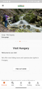
Ghidul turistic online al Ungariei, dezvoltat special pentru drumeții, bicicliști, alergători, alpiniști și iubitorii de sporturi acvatice, cu un planificator de tur încorporat, precum și sute de tururi recomandate și mii de obiective turistice, toate cu descrieri detaliate și o mulțime de fotografii , vizibil confortabil pe o hartă interactivă. Disponibil gratuit, cu o opțiune de abonament pentru funcționalitate extinsă.
Caracteristici
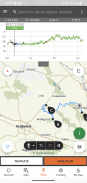
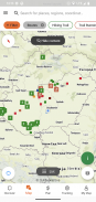
• Diverse hărți de drumeții la nivel mondial interactive, zoomabile, vectorizate, cu toate traseele marcate, arătând poziția dvs. curentă
• O modalitate convenabilă de a planifica propriul tur pe hartă și de a obține imediat lungimea, durata și profilul de altitudine
• Peste o mie de tururi recomandate pentru drumeți, bicicliști, alergători și canoești, cu date practice, descriere detaliată a celor mai bune atracții din apropiere, fundal natural și cultural, fotografii de bună calitate și informații despre cum să ajungeți acolo
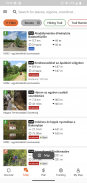
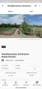
• Mii de atractii turistice recomandate în Ungaria, inclusiv turnuri de belvedere, puncte panoramice naturale, trenuri forestiere, cetăți și muzee, cu descriere detaliată, fotografii de bună calitate, plus informații despre cum să ajungeți acolo
• Sute de cazare, inclusiv cabane, hoteluri turistice și apartamente, lângă trasee marcate
• Colecții utile cu vizualizare pe hartă: plaje din jurul lacului Balaton, arene de patinaj, grădini botenice, cele mai bune trasee de alergare, locuri de alpinism, tururi pentru persoanele cu dizabilități etc.
• Notificări, avertismente și închideri
• Descărcați secțiuni de hărți, tururi și obiective turistice pentru utilizare offline
• navigație din zbor de-a lungul traseului, cu un profil de altitudine live și instrucțiuni vocale
• Înregistrați traseul
• BuddyBeacon: împărtășește-ți poziția prietenilor în direct
• Turul albastru maghiar complet, cu secțiuni oficiale și traseu, puncte de interes și locuri de cazare
• Sincronizează-ți tot conținutul între computer și dispozitivele mobile care rulează aplicația
• Verificați prognoza meteo locală
• zbor 3D: o vedere virtuală a turului
• Instrumente utile încorporate, cum ar fi peak finder(Skyline) și busolă cu poziția dvs. actuală
• Servicii comunitare: evaluează și partajează conținut cu prietenii tăi
Ceasuri inteligente cu sistem de operare WEAR de la Google
Cu o privire la ceasul inteligent, veți obține informații despre poziția dvs. GPS pe hartă. Puteți înregistra trasee, puteți obține date de urmărire și puteți naviga de-a lungul rutelor. Utilizați dala aplicației pentru a accesa cu ușurință rutele din apropiere.
Exclusiv pentru membrii Pro
Mergeți oriunde: Outdooractive Pro funcționează offline fără semnale mobile și de date. De asemenea, pot fi create liste nelimitate, iar aplicația nu are reclame. În plus, puteți vizualiza imagini prin satelit, harta unică Outdooractive cu peste 30 de rețele de trasee de activitate și hărți topografice oficiale de la următorii furnizori:
Marea Britanie Ordnance Survey, Landranger, Explorer
Informații despre terenuri din Noua Zeelandă
Utah USGS
Germania BKG
Austria BEV
Elveția swisstopo
Franța IGN
Spania CNIG
Italia
PDOK din Olanda
Norvegia Kartverket
Danemarca Kortforsyningen
Suedia Lantmäteriet
Finlanda National Land Survey
Japonia GSI
Harta globala
Exclusiv pentru membrii Pro+
Pro+ conține și hărți oficiale de la Asociațiile Alpine, precum și hărți premium de la KOMPASS.
Dacă aveți întrebări sau sugestii, vizitați
https://www.termeszetjaro.hu/hu/p/gyakran-ismetelt-kerdesek/41050512 /
Versiunea noastră pentru desktop:
https://www.termeszetjaro.hu/
Urmăriți-ne pe Facebook:
https://www.facebook.com/Termeszetjaro.hu/
Contactați-ne:
termeszetjaro@termeszetjaro.hu
Mai multe despre cardul TEKA:
http://www.termeszetjarokartya.hu/
Természetjáró, a túratervező - Informații APK
Versiune APK: 3.20.3Pachet: com.outdooractive.mtszCea mai recentă versiune a Természetjáró, a túratervező
Alte versiuni


 4.33
4.33 3.67
3.67

Aplicații din aceeași categorie

S-ar putea să îți placă și...


